Thursday, 19 March 2015


Gurudongmar Lake 

Gurudongmar Lake or Gurudogmar Lake is one of the highest lakes in the world, located at an altitude of 17,100 ft (5,210 m). It lies in the district of North Sikkim in the state of Sikkim in India, only some 5 kilometres (3.1 mi) south of Chinese border. The lake can be reached by road from Lachen via Thangu.


This fresh-water lake is located northeast of the Kangchenjunga range in a high plateau area connected with the Tibetan Plateau. Gurudongmar lake provides one of the source streams of the Teesta River. The source of Teesta, the Tso Lhamo Lake, lies some 5 km (3.1 mi) to the east. One can seek permission from the army to trek from Gurudongmar Lake to Tso Lhsmo Lake.The lake remains completely frozen in the winter months from November to Mid-May.

Monday, 2 March 2015

What are Isolines?
Isolines are lines drawn to link different places that share a common value. The prefix 'iso' is a greek word meaning equal, so an isoline must be a line joining equal points. For example, a line drawn on a map to join up all the places that are the same height above sea level is called a contour. Contour lines are isolines joining places that have the same height value. Another common isoline is the isobar, a line that joins places with the same atmospheric pressure. These are often shown on weather maps in newspapers and TV weather forecasts.
Geographers often use isolines to help them map the distribution of things. When isolines are combined with colouring or shading they make it possible to easily see data that would be hard, or impossible, to understand as a table or chart of numbers.
Apart from contours and isobars there are many more isolines used in geography, although quite a few of them are used only by specialists and they are hardly ever heard of in school.

Here's a list of isolines you might discover as you explore geography ...

Contour Line:Joins points of the same height above ground.

Isobath: Joins points of the same depth below water.
Isobar: Joins points with the same atmospheric pressure.
Isotherm: Joins points with the same temperature.
Isobathytherm: Joins points with the same temperature under water.
Isocheim: Joins points with the same mean temperature in winter.
Isothere: Joins points with the same mean summer temperature.
Isogeotherm: Joins points with the same mean (average) temperature
Isochrone: Joins points that it takes the same time to reach from a given place.
Isodapane: Joins points where it costs the same to transport products from where they are made to where they are sold.
Isotim: Joins points where it costs the same to transport a raw material from its source.
Isohaline: Joins points where the salinity (amount of salt) of sea water is the same.
Isohel: Joins points where the amount of sunshine is the same.
Isohume: Joins points where the humidity (amount of water in the air) is the same.
Isyhyet: Joins points where the amount of precipitation (rainfall, snow etc) is the same.
Isoneph: Joins points where the amount of cloud cover is the same.
Isopectic: Joins places where ice begins to form at the same time each winter.
Isotac: Joins points where ice begins to melt at the same time each spring.
Isoplat: Joins places of equal acidity (used, for example, for mapping acid rain).
Isopleth: Joins points of the same value (as a number), such as population or car ownership.
Isopor: Joins points that have the same annual change in magnetic declination.
Isostere: Joins points with the same atmospheric density.
Isotach: Joins points with the same wind speed.
Isogon: Joins points with the same wind direction.
Isoshear: Joins points that experience the same wind shear.
Isodrosotherm: Joins points of the same dewpoint temperature.
Isoquant: Joints points of equal economic production.
Isophene: Joints points where biological events happen at the same time, such as plants flowering or bulbs emerging.
Isodose: Joins points with the same radiation intensity.
Isogloss: Joins points that share the same linguistic features.
Isochalaz: Joins points with the same frequency of hail storms.
Isobront: Joins points along the front of a storm.
Isophote: Joins points with the same illuminance.
Isochasm: Joins points with the same chance of an aurora occurring.


Wednesday, 25 February 2015

WORLD LARGEST BATTELFIELD

  1. Siachen Glacier
  2. The Siachen Glacier is located in the eastern Karakoram range in the Himalaya Mountains at about 35°25′16″N 77°06′34″E / 35.421226°N 77.109540°E, just northeast of the point NJ9842 where the Line of Control between India and Pakistan ends.
  3. Elevation5,400 m
  4. Area700 km²


Sunday, 22 February 2015

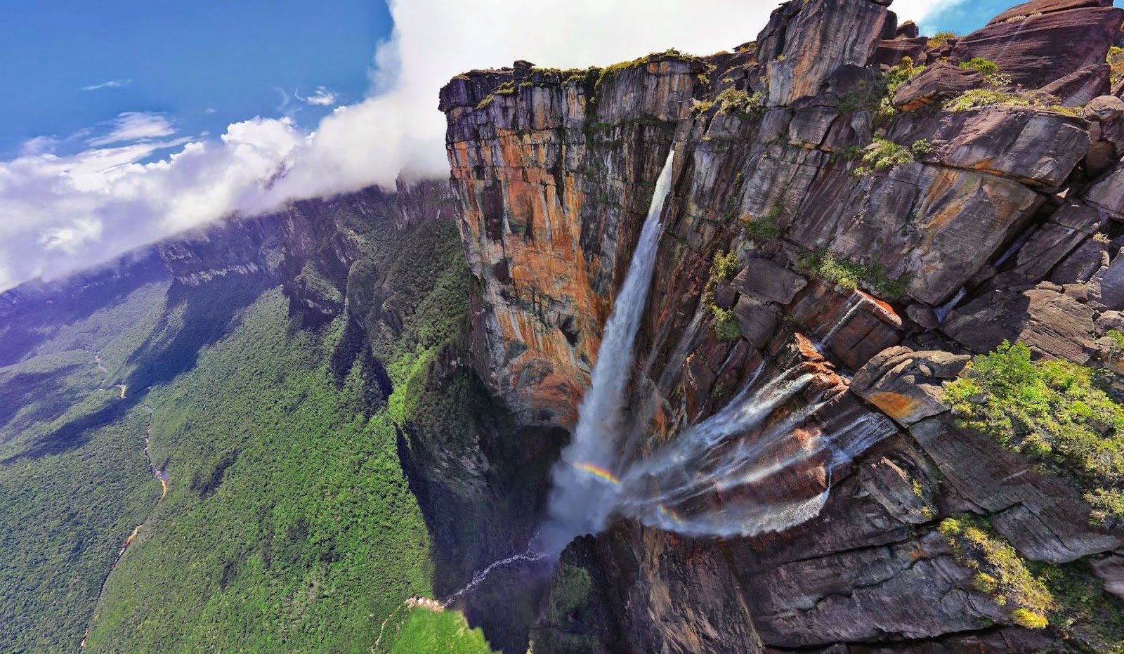
Angel Falls


Angel Falls  is a waterfall in Venezuela. It is the world's highest uninterrupted waterfall, with a height of 979 m (3,212 ft) and a plunge of 807 m (2,648 ft). The waterfall drops over the edge of the Auyantepui mountain in theCanaima National Park (Spanish: Parque Nacional Canaima), a UNESCO World Heritage site in the Gran Sabana region of Bolívar State. The height figure 979 m (3,212 ft) mostly consists of the main plunge but also includes about 400 m (0.25 mi) of sloped cascades and rapids below the drop and a 30-metre (98 ft) high plunge downstream of the talus rapids.
The falls are on the Gauja River (alternatively known as the Kerep River or Kerepacupai), which flows into the Churun River, a tributary of the Carrao River.
The waterfall has been known as the "Angel Falls" since the mid-20th century; they are named after Jimmie Angel, a US aviator, who was the first person to fly over the falls. Angel's ashes were scattered over the falls on 2 July 1960.


Saturday, 21 February 2015

tallest dam in India

The Tehri Dam
is the tallest dam in India and one of the tallest in the world


FACTS ABOUT NIAGARA FALLS


FACTS ABOUT NIAGARA FALLS

Niagara Falls  is the collective name for three waterfalls that straddle the international border between Canada and the United States; more specifically, between the province of Ontario and the state of New York. They form the southern end of the Niagara Gorge.
From largest to smallest, the three waterfalls are the Horseshoe Falls, the American Falls and the Bridal Veil Falls. The Horseshoe Falls lie mostly on the Canadian side and the American Falls entirely on the American side, separated by Goat Island. The smaller Bridal Veil Falls are also located on the American side, separated from the other waterfalls by Luna Island. The international boundary line was originally drawn through Horseshoe Falls in 1819, but the boundary has long been in dispute due to natural erosion and construction.[2]
Located on the Niagara River, which drains Lake Erie into Lake Ontario, the combined falls form the highest flow rate of any waterfallin the world, with a vertical drop of more than 165 feet (50 m). Horseshoe Falls is the most powerful waterfall in North America, as measured by vertical height and also by flow rate.[3] The falls are located 17 miles (27 km) north-northwest of Buffalo, New York and 75 miles (121 km) south-southeast of Toronto, between the twin cities of Niagara Falls, Ontario, and Niagara Falls, New York.
Niagara Falls were formed when glaciers receded at the end of the Wisconsin glaciation (the last ice age), and water from the newly formed Great Lakes carved a path through the Niagara Escarpment en route to the Atlantic Ocean. While not exceptionally high, the Niagara Falls are very wide. More than six million cubic feet (168,000 m3) of water falls over the crest line every minute in high flow,[4] and almost four million cubic feet (110,000 m3) on average.
The Niagara Falls are renowned both for their beauty and as a valuable source of hydroelectric power. Managing the balance between recreational, commercial, and industrial uses has been a challenge for the stewards of the falls since the 19th century.